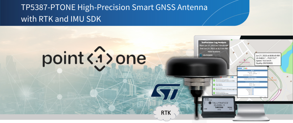
TP5790-PTONE SDK – High Precision Smart GNSS Antenna with Inertial Measurement Unit and RTK
Calian’s High Precision Tallysman Smart GNSS antennas integrate advanced receivers with High Precision Tallysman GNSS antennas, connecting Position, Navigation and Timing resources to host systems over digital interfaces. BUY ONLINE.
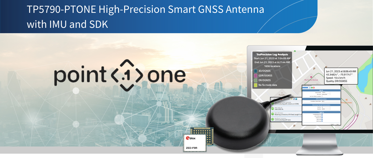
Calian’s High Precision Tallysman Smart GNSS antennas integrate advanced receivers with High Precision Tallysman GNSS antennas, connecting Position, Navigation and Timing resources to host systems over digital interfaces.
Calian Smart GNSS SDK’s are a plug and play evaluation platform for Calian’s Smart Antennas, with tools such as: TruPrecision Software, a 1-year complimentary license to Polaris RTK corrections from Point One Navigation and simple connection to a PC.
The TP5790SDK-PTONE supports the TW5790 High Precision GNSS Smart Antenna with IMU. It features:
- NMEA monitoring, satellite visibility and signal strength, GNSS status monitoring, Inertial Measurement Unit monitoring and logging tools, with visual state heat-map
- Status console to pinpoint issues between antenna, connections and network corrections
Get a free year of GNSS Corrections for your Calian Antenna
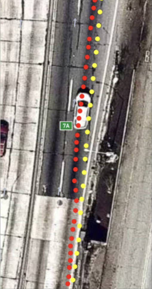
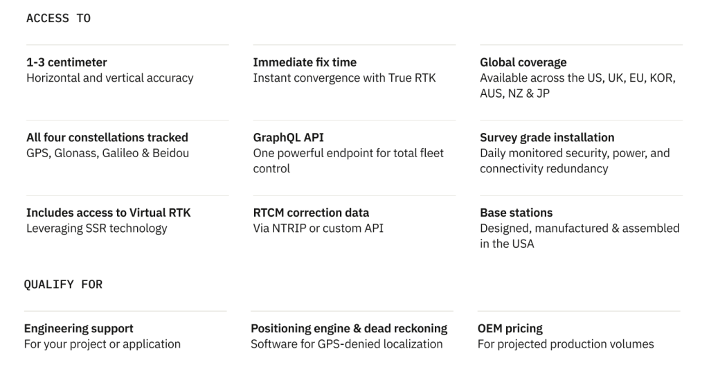
Access centimeter-level accuracy with the world’s largest, professionally-run RTK and SSR corrections network. Get unmatched coverage, accuracy, and reliability while making your device 100x times more accurate than traditional GNSS.
With an actively monitored and remotely managed network of thousands of base stations that have 99.9% uptime, reliability is something you’ll never have to question. With Point One Navigation, you can integrate your location data via our web applications or build your own with the Point One API. A powerful, modern single endpoint GraphQL API that lets you provision, manage, and deploy as you scale. And, enjoy access to a responsive global beacon-on-demand program to reach even the most challenging environments.
Learn more about Polaris at https://pointonenav.com/calian-dev-kit
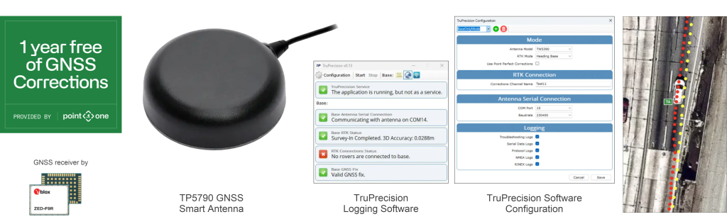
TP5790-PTONE Precise Heading SDK includes:
- 1 x Calian TW5790 Smart GNSS High Precision (with IMU) antenna (see below ordering information)
- 1 x 23-0067-14: ten cm ground plane
- Calian TruPrecision Application for Software Development and Verification
- 1-year complimentary license to Polaris RTK corrections from Point One Navigation
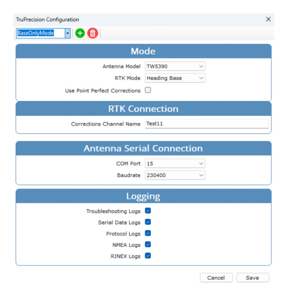
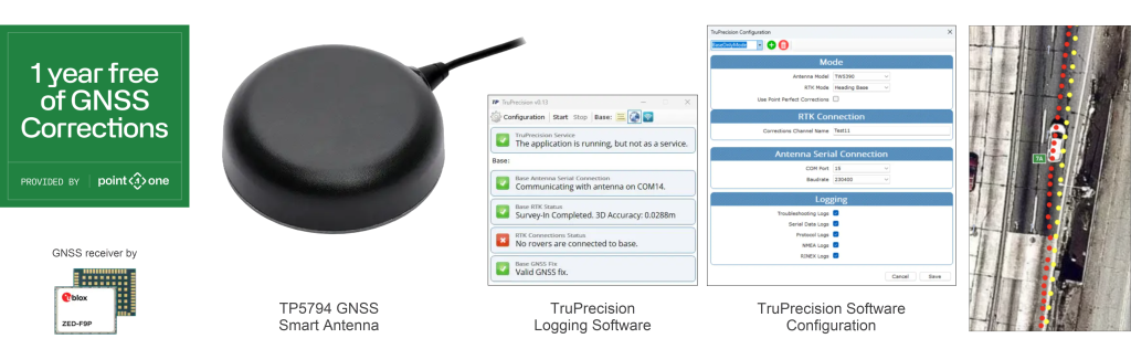
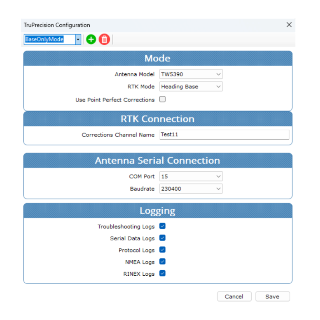
The TruPrecison SDK application is a Windows application to provision your new TW5790 Smart Antenna with a connection and license to Polaris RTK corrections from Point One Navigation. Once provisioned, the antenna continuously generates high precision “corrected” position data output as NMEA or UBX formatted messages. The included USB-to-Serial Bridge provides a virtual COM port to allow customers to connect their onboard navigation and mapping applications to receive these messages from the Calian Smart GNSS Antenna in real-time. ROS2® Drivers are available for integration with ROS2 open framework projects.
TP5387SDK-PTONE High-Precision Smart L1/L5 GNSS SDK
Calian’s TW5387 High Precision Tallysman Smart L1/L5 GNSS Antenna with Point One Navigation’s centimeter accurate Polaris RTK corrections provides the instant-on solution for L1/L5 and cPNT applications that need the fastest fix in the industry. BUY ONLINE
Calian’s High Precision Tallysman Smart GNSS antennas integrate advanced receivers with High Precision Tallysman GNSS antennas, connecting position, navigation and timing resources to host systems over digital interfaces. The TW5387 Software Development Kit (SDK) with Polaris RTK corrections from Point One Navigation supports the TW5387 High Precision L1/L5 Smart GNSS Antenna, which incorporates a Quectel LG69TAP receiver module with onboard ST TESEO V receiver and Inertial Measurement Unit (IMU). The SDK includes Calian’s GNSS dashboard/evaluation software TruPrecision. It also includes a 1-year complimentary license to Polaris RTK corrections from Point One Navigation, with an easy process for quickly applying RTK corrections to your TW5387 Smart antenna..
Get a free year of GNSS Corrections for your Calian Antenna
Access centimeter-level accuracy with the world’s largest, professionally-run RTK and SSR corrections network. Get unmatched coverage, accuracy, and reliability while making your device 100x times more accurate than traditional GNSS.
With an actively monitored and remotely managed network of thousands of base stations that have 99.9% uptime, reliability is something you’ll never have to question. With Point One Navigation, you can integrate your location data via our web applications or build your own with the Point One API. A powerful, modern single endpoint GraphQL API that lets you provision, manage, and deploy as you scale. And, enjoy access to a responsive global beacon-on-demand program to reach even the most challenging environments.
Learn more about Polaris at https://pointonenav.com/calian-dev-kit

TP5387SDK-PTONE Precision GNSS Antenna with IMU SDK includes:
- 1 x Calian TW5387 Smart GNSS High Precision (IMU) antenna (see below ordering information)
- 1 x 23-0067-0: 10 cm ground plane
- Calian TruPrecision Application for Software Development and Verification
- 1-year complimentary license to Polaris RTK corrections from Point One Navigation
The TruPrecison SDK application is a Windows application to provision your new TW5387 Smart Antenna with a connection and license to Polaris RTK corrections from Point One Navigation. Once provisioned, the antenna continuously generates high precision “corrected” position data output as NMEA formatted messages. The included USB-to-Serial Bridge provides a virtual COM port to allow customers to connect their onboard navigation and mapping applications to receive these messages from the Calian Smart GNSS Antenna in real-time.
TP5794-PTONE Moving Base Precise Heading SDK
Calian’s TW5794 Smart GNSS Precise Heading Antenna with Point One Navigation Polaris RTK Service is the Plug and Play solution for Precise Heading evaluation. BUY ONLINE

The TW5794-PTONE Precise Heading SDK is the best way to get started. It includes a TW5794 Smart GNSS Precise Heading Antenna with USB to connect into your PC. TruPrecision software simplifies the User Interface to the antenna’s GNSS receiver, and provides extras such as logging tools, GNSS signal strength graphs, and tools for local Base/Rover RTK. It also includes a 1-year complimentary license to Polaris RTK corrections from Point One Navigation, with an easy process for quickly applying Polaris corrections to your SDK antenna.
Get a free year of GNSS Corrections for your Calian Antenna
Access centimeter-level accuracy with the world’s largest, professionally-run RTK and SSR corrections network. Get unmatched coverage, accuracy, and reliability while making your device 100x times more accurate than traditional GNSS.
With an actively monitored and remotely managed network of thousands of base stations that have 99.9% uptime, reliability is something you’ll never have to question. With Point One Navigation, you can integrate your location data via our web applications or build your own with the Point One API. A powerful, modern single endpoint GraphQL API that lets you provision, manage, and deploy as you scale. And, enjoy access to a responsive global beacon-on-demand program to reach even the most challenging environments.
Learn more about Polaris at https://pointonenav.com/calian-dev-kit
TP5794-PTONE Precise Heading SDK includes:
- 1 x Tallysman TW5794 Smart GNSS Precise Heading antenna with USB or RS-232 (see below ordering information)
- 1 x 23-0067-14: ten cm ground plane
- Calian’s TruPrecision Application for Software Development and Verification
- 1-year complimentary license to Polaris RTK corrections from Point One Navigation.
The TruPrecison SDK application is a Windows application to provision your new TW5794 Smart Antenna with a connection and license to Polaris RTK corrections from Point One Navigation. Once provisioned, the antenna continuously generates high precision “corrected” position data output as NMEA or UBX formatted messages. The included USB-to-Serial Bridge provides a virtual COM port to allow customers to connect their onboard navigation and mapping applications to receive these messages from the Calian Smart GNSS Antenna in real-time. ROS2® Drivers are available for integration with ROS2 open framework projects.
TW3885TL Multi-Constellation Dual-Band Timing Antenna (built-in Lightning Arrestor)
The TW3885TL is a precision-tuned dual-band, Accutenna® technology, timing antenna providing GPS/QZSS-L1/L5, GLONASS-G1/G3, Galileo-E1/E5a/E5b, BeiDou-B1/B2a/B2 and NavIC-L5, including the satellite-based augmentation system (SBAS) available in the region of operation [WAAS (North America), EGNOS (Europe), MSAS (Japan), or GAGAN (India)].
Applications
- Precise Timing
Features
- Very low noise preamp (< 2.5 dB typ.)
- Low axial ratio (< 2.0 dB typ.)
- Tight phase centre variation
- High-gain LNA (40 dB typ.)
- Low current (32 mA typ.)
- Invariant performance from 2.5 to 16 VDC
- 5 kA, 8/20 μs built-in lightning arrestor
Benefits
- Excellent multipath rejection
- Increased system accuracy
- Excellent signal-to-noise ratio
- Built-in surge protection
- CE RED, RoHS, and REACH compliant
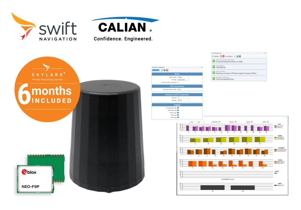
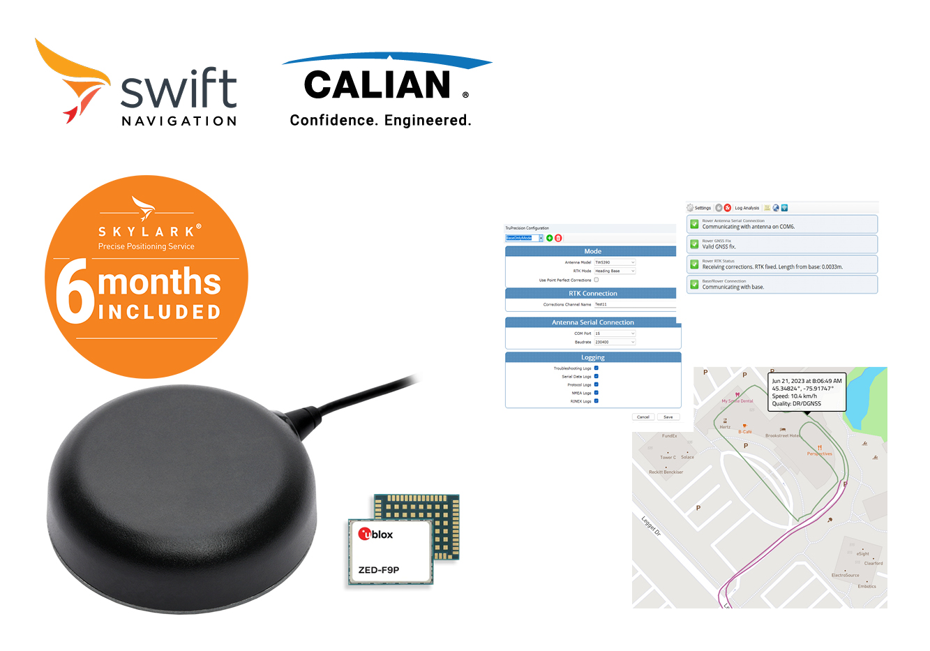
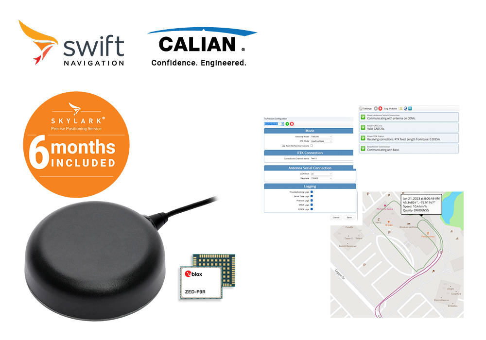
TP5387-SWNAV High-Precision Smart L1/L5 GNSS SDK
Calian’s TW5387 High Precision Tallysman Smart L1/L5 GNSS Antenna with Swift Navigation Skylark Precise Positioning Service is the Plug and Play solution for L1/L5 and cPNT applications. BUY ONLINE
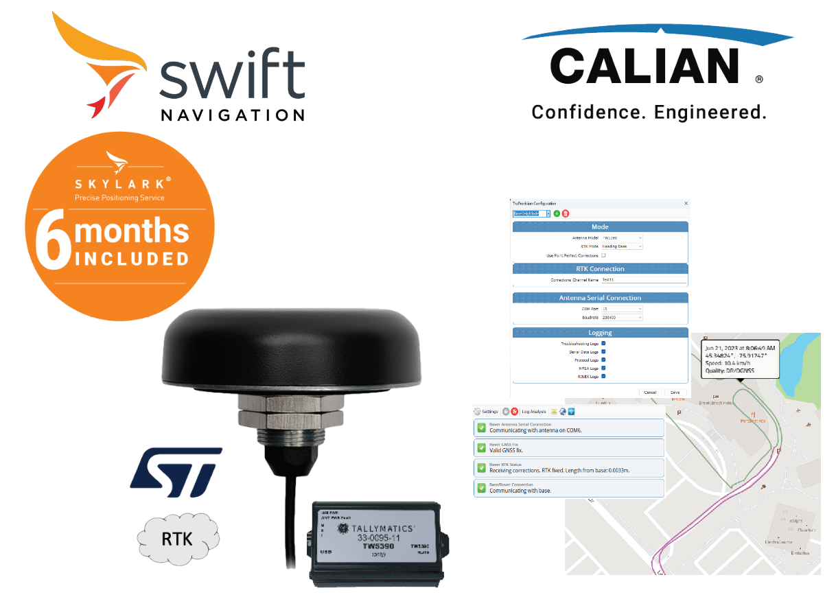
Calian’s High Precision Tallysman Smart GNSS antennas integrate advanced receivers with High Precision Tallysman GNSS antennas, connecting Position, Navigation and Timing resources to host systems over digital interfaces. The TW5387 Software Development Kit (SDK) for Swift Navigation’s Skylark Precise Positioning Service supports the TW5387 High Precision L1/L5 Smart GNSS Antenna, which incorporates a Quectel LG69TAP receiver module with onboard ST TESEO V receiver and Inertial Measurement Unit (IMU). The SDK includes Calian’s GNSS dashboard/evaluation software TruPrecision. It also includes 6 months of complementary access to Swift Navigations’s Skylark Cx Precise Positioning Service with an easy process for quickly applying Skylark corrections to your GNSS Antenna.

Swift Navigation’s Skylark® Precise Positioning Service is a global, cloud-based GNSS corrections service that delivers reliable precision continent-wide. Designed to meet diverse application needs, Skylark is available in three distinct variants—Skylark Cx, Nx RTK, and Dx—each optimized for specific use cases, ensuring the right balance of performance and practicality.
Skylark Cx is a PPP-RTK corrections service that delivers uniform centimeter-level accuracy across continents. With 3–7 cm accuracy and a fast convergence time of under 20 seconds, its performance remains consistent, regardless of distance from base stations—providing seamless accuracy at a national and continental scale.
Learn more about Skylark at https://www.swiftnav.com/products/skylark
TP5387-SWNAV Precision GNSS Antenna with IMU SDK includes:
- 1 x Calian TW5387 Smart GNSS High Precision (IMU) antenna (see below ordering information)
- 1 x 23-0067-0: 10 cm ground plane
- Calian TruPrecision Application for Software Development and Verification
- 6 month trial subscription to the Swift Navigation Skylark Cx Precise Positioning Service
The TruPrecison SDK application is a Windows service which provides an autonomous connection to stream Skylark corrections to the TW5387 Smart Antenna via a USB to Serial Bridge which also provides a Virtual COM Port to allow customers to connect their existing applications to the Calian Smart GNSS Antenna high precision “corrected” position data output as NMEA formatted messages.
.

HCS885XF-SWNAV L1/L5 Smart GNSS Helical SDK
Calian’s HCS885XF Smart GNSS Helical Antenna is the Plug and Play, light weight, low power L1/L5 solution for Handheld Devices, Robots and Drones. BUY ONLINE.
The HCS885XFSDK Smart GNSS Helical SDK is the best way to fast track precise location and heading in your project. The L5 enhanced signal architecture with stronger broadcast signal offers more precise standard localization and improved multi-path mitigation while operating in an ITU/ARNS aviation band with regulatory interference protection. The SDK includes one* HCS885XF Smart GNSS Precise Heading Helical Antenna with serial to USB bridge to connect to your PC. TruPrecision software simplifies the User Interface to the antenna’s GNSS receiver, and provides extras such as logging tools, GNSS signal strength graphs and message routing for sharing RTCM between base and rover antenna pairs across the internet. It also includes a 6 month complementary access to Swift Navigation’s Skylark Cx Corrections, with an easy process for quickly applying corrections (RTK or PPP-RTK) to the antenna. ROS2® drivers also available.
Swift Navigation’s Skylark® Precise Positioning Service is a global, cloud-based GNSS corrections service that delivers reliable precision continent-wide. Designed to meet diverse application needs, Skylark is available in three distinct variants—Skylark Cx, Nx RTK, and Dx—each optimized for specific use cases, ensuring the right balance of performance and practicality.
Skylark Cx is a PPP-RTK corrections service that delivers uniform centimeter-level accuracy across continents. With 3–7 cm accuracy and a fast convergence time of under 20 seconds, its performance remains consistent, regardless of distance from base stations—providing seamless accuracy at a national and continental scale.
Learn more about Skylark at https://www.swiftnav.com/products/skylark
HCS885XFSDK Smart GNSS Helical SDK includes:
- 1 x Tallysman 33-HCS885XF-49 Smart GNSS Precise Heading helical antenna with CMOS interface
- Calian TruPrecision Application for Software Development and Verification
- 6 month trial subscription to the Swift Navigation Skylark Cx Precision Positioning service
- 1 x JST to USB cable
- Ordering Information:
- 33-HCS885XFSDK-SWNAV-4 (CMOS)
- 33-HCS885XFSDK-SWNAV-2 (RS-232)
The TruPrecison SDK application is a Windows application which provides an NTRIP connection to stream Skylark corrections to the HCS885XF Smart Antenna via USB, which also provides a Virtual COM Port to allow customers to connect their existing applications to the Tallysman HCS885XF Smart GNSS Precise Heading Antenna high precision “corrected” position data output. The position data may be either NMEA or UBX formatted messages. ROS2® Drivers are available for integration with ROS2 open framework projects.

ROS2® Drivers
https://github.com/Calian-gnss/calian-gnss-ROS2-drivers

TP5794-SWNAV Precise Heading SDK
Calian’s TW5794 Smart GNSS Precise Heading Antenna with Swift Navigation Skylark Precise Positioning Service is the Plug and Play solution for Precise Heading evaluation. BUY ONLINE
The TW5794 Precise Heading SDK is the best way to get started. It includes a TW5794 Smart GNSS Precise Heading Antenna with USB to connect into your PC. TruPrecision software simplifies the User Interface to the antenna’s GNSS receiver, and provides extras such as logging tools, GNSS signal strength graphs, and tools for local Base/Rover RTK. It also includes 6 months of complementary access to Swift Navigation’s Skylark Precise Positioning Service with an easy process for quickly applying Skylark corrections to your SDK antenna.
Swift Navigation’s Skylark® Precise Positioning Service is a global, cloud-based GNSS corrections service that delivers reliable precision continent-wide. Designed to meet diverse application needs, Skylark is available in three distinct variants—Skylark Cx, Nx RTK, and Dx—each optimized for specific use cases, ensuring the right balance of performance and practicality.
Skylark Cx is a PPP-RTK corrections service that delivers uniform centimeter-level accuracy across continents. With 3–7 cm accuracy and a fast convergence time of under 20 seconds, its performance remains consistent, regardless of distance from base stations—providing seamless accuracy at a national and continental scale.
Learn more about Skylark at https://www.swiftnav.com/products/skylark
TP5794-SWNAV Precise Heading SDK includes:
- 1 x Tallysman TW5794 Smart GNSS Precise Heading antenna with USB or RS-232 (see below ordering information)
- 1 x 23-0067-14: ten cm ground plane
- Calian TruPrecision Application for Software Development and Verification
- 6 month trial subscription to the Swift Navigation Skylark Cx Precise Positioning Service
The TruPrecison SDK application is a Windows application which provides an NTRIP connection to stream Skylark corrections to the TW5794 Smart Antenna via the the USB, which also provides a Virtual COM Port to allow customers to connect their existing applications to the Tallysman TW5794 Smart GNSS Precise Heading Antenna high precision “corrected” position data output. The position data may be either NMEA or UBX formatted messages. ROS2® Drivers are available for integration with ROS2 open framework projects.
ROS2® Drivers
https://github.com/Calian-gnss/calian-gnss-ROS2-drivers
TP5790-SWNAV SDK – High Precision Smart GNSS Antenna with Inertial Measurement Unit and RTK
Calian’s High Precision Tallysman Smart GNSS antennas integrate advanced receivers with High Precision Tallysman GNSS antennas, connecting Position, Navigation and Timing resources to host systems over digital interfaces. BUY ONLINE.
Calian’s High Precision Tallysman Smart GNSS antennas integrate advanced receivers with High Precision Tallysman GNSS antennas, connecting Position, Navigation and Timing resources to host systems over digital interfaces.
Calian Smart GNSS SDK’s are a plug and play evaluation platform for Calian’s Smart Antennas, with tools such as: TruPrecision Software, 6 month complementary Swift Navigation Skylark Cx correction services and simple connection to a PC.
The TW5790SDK supports the TW5790 High Precision GNSS Smart Antenna with IMU. It features:
- NMEA monitoring, satellite visibility and signal strength, GNSS status monitoring, Inertial Measurement Unit monitoring and logging tools, with visual state heat-map
- Status console to pinpoint issues between antenna, connections and network corrections
Swift Navigation’s Skylark® Precise Positioning Service is a global, cloud-based GNSS corrections service that delivers reliable precision continent-wide. Designed to meet diverse application needs, Skylark is available in three distinct variants—Skylark Cx, Nx RTK, and Dx—each optimized for specific use cases, ensuring the right balance of performance and practicality.
Skylark Cx is a PPP-RTK corrections service that delivers uniform centimeter-level accuracy across continents. With 3–7 cm accuracy and a fast convergence time of under 20 seconds, its performance remains consistent, regardless of distance from base stations—providing seamless accuracy at a national and continental scale.
Learn more about Skylark at https://www.swiftnav.com/ products/skylark
TP5790-SWNAV Precision GNSS Antenna with IMU SDK includes:
- 1 x Calian TW5790 Smart GNSS High Precision (with IMU) antenna (see below ordering information)
- 1 x 23-0067-14: ten cm ground plane
- Calian TruPrecision Application for Software Development and Verification
- 6 month trial subscription to the Swift Navigation Skylark Cx Precise Positioning Service
The TruPrecison SDK application is a Windows application which provides an autonomous connection to stream PointPerfect IP or N-RTK corrections and decryption keys to the TW5790 Smart Antenna via a USB connection, which also provides a Virtual COM Port to allow customers to connect their existing applications to the Calian Smart GNSS Antenna high precision position data output. The position data may be either NMEA or UBX formatted messages..
ARM990XF Multi-Constellation Full-Band Antenna
Calian is excited to announce that it has added the ARM990XF full-band plus L-Band GNSS antenna to its industry-leading line of GNSS antenna products. The ARM990XF employs Calian’s patented Accutenna® technology providing GPS/QZSS L1/L2/L5/L6, GLONASS-G1/G2/G3, Galileo E1/E5a/E5b/E6, and BeiDou B1/B2a/B2b/B3, NavIC L5 + L-Band coverage. The ARM990XF antenna is designed for precision full-frequency positioning where lightweight and a low profile are important.
The ARM990XF antenna is available in two form factors one includes a 100 mm integrated ground plane, weighing 140 g, and the other one is 83mm in diameter and weighs 138 grams. Both are 19 mm tall and support the ARINC mini bolt pattern of 2.0” x 1.66”. Calian’s ARM990XF is one of the smallest and lightest housed triple-band precision Mini ARINC GNSS antennas on the market. It has a very tight average phase center variation of less than 10 mm for all frequencies and overall azimuths and elevation angles. In addition to supporting two form factors both models are available with Low Earth Orbit (LEO) qualified components.
Housed in a weatherproof enclosure, the ARM990XF is available in four versions. Model ARM990XF-1 has an integrated 100mm ground plane, Model ARM990XF-2 is 83 mm in diameter. All models are available with either a female SMA or TNC connector.
The new ARM990XF antenna supports Calian’s eXtended Filtering (XF) technology. Worldwide the radio frequency spectrum has become congested as many new LTE bands have been activated, and their signals or harmonic frequencies can affect GNSS antennas and receivers. In North America, the planned Ligado service, which will broadcast in the frequency range of 1526 to 1536 MHz, can affect GNSS signals. Similarly, new LTE signals in Europe [Band 32 (1452 – 1496 MHz)] and Japan [Bands 11 and 21 (1476 – 1511 MHz)] have also affected GNSS signals. Calian’s XF technology mitigates all these signals.
Applications
- Autonomous vehicle tracking and guidance
- Precise GNSS positioning
- Precision agriculture
- Full-frequency RTK and PPP receivers
- Law enforcement and public safety
- Augmented GNSS positioning
Features
- Very low noise preamp (< 2.5 dB typ.)
- Tight phase centre variation
- High-gain LNA (28 or 33 dB typ.)
- Low current (32 mA typ.)
- ESD circuit protection (15 kV)
- Invariant performance from 2.5 to 16 VDC
- IP69K, REACH, and RoHS compliant
Benefits
- Excellent interference mitigation
- Excellent multipath rejection
- Increased system accuracy
- Excellent signal-to-noise ratio
ARM960P Multi-Constellation Triple-Band Antenna
Calian is excited to announce that it has added the ARM960P triple-band plus L-Band GNSS passive antenna to its industry-leading line of GNSS antenna products. The ARM960P employs Calian’s patented Accutenna® technology providing GPS/QZSS L1/L2/L5, GLONASS-G1/G2/G3, Galileo E1/E5a/E5b, and BeiDou B1/B2a/B2b + L-Band coverage. The ARM960P antenna is designed for precision triple-frequency positioning where lightweight and a low profile are important.
The ARM960P antenna is available in two form factors one includes a 100 mm integrated ground plane, weighing 140 g, and the other one is 83mm in diameter and weighs 138 grams. Both are 19 mm tall and support the ARINC mini bolt pattern of 2.0” x 1.66”. Calian’s ARM960P is one of the smallest and lightest housed triple-band precision Mini ARINC GNSS antennas on the market. It has a very tight average phase center variation of less than 10 mm for all frequencies and overall azimuths and elevation angles. In addition to supporting two form factors both models are available with Low Earth Orbit (LEO) qualified components.
Housed in a weatherproof enclosure, the ARM960P is available in four versions. Model ARM960P-1 (ARM960P-1-S LEO Space qualified components) has an integrated 100mm ground plane, Model ARM960P-2 (ARM960P-2-S LEO Space qualified components) is 83 mm in diameter. All models are available with either a female SMA or TNC connector.
Applications
- Autonomous vehicle tracking and guidance
- Precise GNSS positioning
- Precision agriculture
- Triple-frequency RTK and PPP receivers
- Law enforcement and public safety
- Augmented GNSS positioning
Features
- Tight phase centre variation
- IP69K (non-space), REACH, and RoHS
Benefits
- Excellent interference mitigation
- Excellent multipath rejection
- Increased system accuracy
- Excellent signal-to-noise ratio